Contribute  Loading...
Children Loading... Geography Parents Loading... Routes Routes
| Lion Head   | 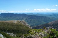
| Page Type: Route Location: New Hampshire, United States, North America Lat/Lon: 44.27060°N / 71.3047°W Route Type: Hike / Snow Climb Time Required: Half a day Difficulty: Class 1 (YDS)
Loading... | Route Quality: | | | |
| Page By: John Created/Edited: Sep 11, 2001 / Oct 22, 2004 Object ID: 155770 Hits: 8621 Loading... Page Score: 83.24% - 3 Votes Loading... Vote: Log in to vote |
Approach
Same as the Tuckerman Ravine Trail: Use the Pinkham Notch Visitor Center described in the Getting There section. Follow the trail around the left side of the visitor center to find the trailhead. You will quickly run into a sign telling you of the current avalanche dangers on various routes.
Route Description
The Lion Head Trail is a variation of the Tuckerman Ravine route that avoids climbing the actual ravine by climbing the Lion Head, a knob on the ravine's north rim which offers excellent views. This is the most popular winter ascent route for non-skiers or skiers wishing to ski down Tucks but with an easier ascent.
Follow the Tuckerman Ravine Trail from the Pinkham Notch Visitor Center (2050') for 2.3 miles until you reach the well signed junction with the Lion Head Trail (3825') on your right side. Take this trail up Lion Head and along Tuckerman Ravine's north rim before asending a gentle slope rejoining the Tuckerman Ravine trail in 1.6 miles. From here follow the Tuckerman Ravine Trail 0.4 miles north to the summit (6288'). The trail should be YDS class 1 all the way, however if you get off trail, you may encounter some class 2.
Essential Gear
None during the snow-free season though a windproof / waterproof jacket is nice to have on hand since the weather can change fairly quickly.
During the winter an ice axe and crampons are recommended. Since the Lion Head Trail leaves the Tuckerman Ravine Trail before Hermit Lake you won't run into the rangers that are stationed there.
Winter Variation
Description from GuitarWIzard:
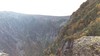
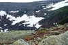
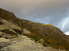
The Winter Route is perhaps the most popular route up the mountain; on a fair winter day, expect to see dozens of people. Leaving Pinkham Notch at 6 a.m. almost guarantees that you will see very few, if any, others on the ascent. While a mountaineering axe and crampons are the only "required" equipment, I have only done it once with just a mountaineering axe....vowed never to do that again. Using ice climbing tools makes it MUCH easier and a lot quicker, particularly if there's some mixed climbing sections of rock, snow and ice. For the most part, you'll use the French step and grip the axes on the heads and make your way up, but there are a few sections in which you'll use your picks. About halfway up, there are some fairly steep sections that can get a little tricky if not a ton of snow. There's a nice 70-75 degree slope for a good 10-15 feet on one section, but there's usually a detour that goes around it. However, if you have ice climbing tools, it's fun to go up. If you go at a steady pace, you can make it to treeline from the start of the Winter Route in about 50 minutes. Treeline to Lion Head (the large rocks at 5,000 feet) takes between 40 minutes to an hour....the rocks provide a good shelter to rest, grab some food, or change clothing. Just past the rocks, the wind can pick up severely. On one particular ascent, winds at the summit were only 35mph, but the SW winds sweeping across the flat ridge between Lion Head and the Alpine Garden junction were averaging around 80 mph and gusting to 100 mph. The wind typically clears about 90% of the snow on this stretch, so walking in those winds on small rocks can be quite a challenge. Once past the Alpine Garden junction, you will ascend the snowfield, passing through Split Rock. Depending on the snow depth, it can be a good ascent (no postholing), or a nightmare (up to your chest during or after a good storm). You will meet back up with the Tuckerman Ravine trail about 100 yards or so past Split Rock....if the legs are feeling good and the trail is well packed, you can be at the summit in under 30 minutes. On the descent, you can pull out the mountaineering axe and glissade down the Lion Head Winter Route for about 85% of it, depending on the snow conditions and if there's a train of people climbing up. There are a few sections that will require walking and climbing down, due to either being too steep, or not steep enough.
This route is perhaps the least avalanche-prone route to the summit. There is an avalanche cache at the bottom the the Lion Head Winter Route. While it's a fairly moderate climb that most abilities can tackle, you can still fall and get quite injured on some of the steeper sections. The route is well marked with blue markers, and above treeline has reflective orange markers for locating the route at night (which is very helpful, particularly in a storm). The trail is approximately 1.75 miles from Pinkham Notch, and starts on the Huntington Ravine Fire Road.
Miscellaneous Info
If you have information about this route that doesn't pertain to any of the other sections, please add it here.
Images
|
|
 Mount Washington
.jpg)

.jpg)
.JPG)


