|
Mystery Canyon
Mystery is my favorite Zion canyon.
Oh my heck, it has everything – a rough-tough smackdown approach; a verdant, wooded canyon with spectacular soaring walls; multiple rappels through intimate, sculpted narrows; some walking in the hot sun; a monstrous rockfall that creates a seasonal lake; a big rappel into a pool; wading pools in a jungle paradise; and finally a slippery slab rappel to the whirring camcorders of numerous tourists. Not too long, not too short - Mystery is a great outing.
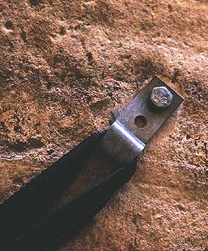
Though information is sketchy, Mystery was probably first descended in the 1960s. “Interesting” anchors attest to the improvisatory skills of early descentionists, including chunks of rebar pounded into drilled holes. Anchors in Mystery are generally fixed, though judgment is required to figure out which of the antique anchors to use. An interesting feature of the canyon is a giant sand pile created by a landslide in the early 70’s – a 400-foot pile of rock and sand that dams the canyon and creates a "Devil’s Hole". On occasion, the lake before the slide is up to 10 feet deep and provides a long and stimulating swim. Most of the time it is dry or a boggy gumbo. This small "lake" is similar to larger lakes that had a profound effect on Zion's topography in the geologically recent past.
Mystery can be approached from either the Weeping Rock shuttle stop in the main canyon or from the East Mesa trailhead on the Zion Ponderosa Ranch. The second option saves you 2100 feet (640m) of climbing on a steep trail, but requires a car shuttle. Mystery is a popular canyon, and permits can be hard to get. Expect to share the canyon with other parties, especially on weekends.
Due to its popularity, Mystery is managed under a quota system. Reservations are distributed by lottery several months in advance and are recommended. Visit the Permit System Website to get in on the lottery or to make reservations. Call the Backcountry Desk (435-772-0170) for the latest information. If you do not have reservations, don't fret - there are SOMETIMES permits available one day in advance of, or the day of, your hike at the Main and Kolob Canyons Visitor Centers. Be flexible and plan ahead to avoid being denied. Group size limit is six.
| Rating: | | 3B III  |
| Season: | | Summer or Fall. |
| Length: | | 5 to 8 hours. |
| Longest Rappel: | | 120 feet (36 meters) |
| Cold water protection: | | Dry bags for your gear. Wetsuits useful in all but the hottest weather. |
| Drinking Water: | | Carry your own. Water is found at Mystery Springs and can be filtered. |
| Map: | | Temple of Sinawava |
| Logistics: | | Easy: Start at Weeping Rock and end at Temple of Sinawava. Take the shuttle.
More Difficult: Use East Mesa Trailhead to save yourself 2100 feet of climbing. Requires car shuttle.
|
| Permit: | | Required. |
| Flash Flood Danger: | | Moderate. Weather Report available at Visitor Center. |
| Local Ethics: | | Zion is a bolts-accepted area, however, there seem to be plenty in Mystery, so please do not add more. In the dry narrows section, choose your anchors carefully - some of that hardware is of museum quality. |
|
Gear and Difficulties
Mystery has about 12 rappels up to 120 feet (40m) in length. Bring 20 to 30 feet of webbing and rapid links in case slings are missing or damaged. Bring drybags or dry kegs for your gear – there can be two mandatory swims near the end. The swims are short, so wetsuits are not required if the weather is hot and the lake is dry. In the spring and fall, wetsuits are highly recommended. Mystery does have an exposed traverse that most parties will want to protect using a safety/zip line or a belay. Each member of the party will need a tether and locking carabiner to clip the zip line. There is no drinking water in the canyon until the very end - bring your own.
Finding the top of Mystery can be a problem, so bring a map and use it. I’d like to think these directions alone are sufficient, but they are not. One or two parties a year start down the next drainage to the west (Miss-me), thinking they are in Mystery, and end up requiring a rescue. Make certain you are in the right place before heading down. If the approach does not look well-traveled, you are in the wrong place – go back!
| |
|
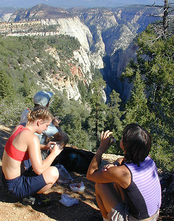
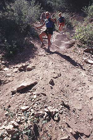
| | Taking a quick rest before descending into the head of Mystery Canyon. | Getting There
From Zion Canyon/Weeping Rock: get an early start to avoid the heat. From Weeping Rock, ascend the Observation Point Trail. The trail switchbacks up the mountain below the face of Cable Mountain, then cuts left into Echo Canyon, briefly following the streambed before climbing up the side on a cutout and getting back into the sun. More climbing across mixed slickrock and brush leads to the base of a buttress. Climb steeply up the buttress, switchbacking to the rim of the mesa. The trail follows the rim west toward Observation Point. One-third mile from Observation Point, the East Mesa Trail comes in on the right – this takes you to Mystery Canyon. Allow 2 hours to climb to the trail junction – (2.7 miles (4.3 km), ascent of 2100 feet (640m)) – most of which is in the full sun after mid-morning.
The stroll out to Observation Point (1/3 mile, 1/2 km) provides a dramatic view of Zion Canyon, and is well worth a 45-minute diversion, if not pressed for time.
From the trail junction, follow the East Mesa Trail north then east through brush and ponderosa pines. After 20 minutes, and just after passing the trail’s highpoint, a gorge can be seen through the brush to the left, starting about 30 feet (10m) from the East Mesa Trail. Numerous small trails lead to the rim – follow them to the apex of Mystery Canyon.
Getting There, Ponderosa Ranch Approach
The East Mesa Trail begins on the Park Boundary and is accessed through the Zion Ponderosa Ranch Resort. Allow an hour driving time from Springdale.
From Springdale, take Route 9 up Pine Creek Canyon toward Mt Carmel Junction. From the East Entrance, continue 2.4 miles east, then turn Left (N) on the paved North Fork Road. Follow the winding road 5.1 miles to the Zion Ponderosa Ranch Resort - turn left into the Ranch. The following mileage points are given from the entrance.
The dirt roads from here are rough and not well signed. Please be respectful of Ponderosa residents you encounter - afoot, on ATV, on horse or in cars. You are a guest on the Ranch. A few, but not all, of the turns are marked for "Observation Point".
- 0.0 miles: At the entrance, go straight (avoid going down to the main resort building to the left) past a residence. Pavement ends.
- 0.4 miles: Y - go Right.
- 0.7 miles: T - go Right for Observation Point (Twin Knolls Road).
- 1.5 miles: T - go Right.
- 2.3 miles: Fir Road crosses - go straight. Road gets worse. Stop here if the road is wet.
- 2.6 miles: Deeply rutted hill - this is the worst spot. Some 2WDs will want to park at the top of the hill.
- 2.65 miles: Big Pine in center of road, rough. Go Left around pine, then Right down the hill.
- 2.9 miles: Y - go Left for East Mesa Trailhead
- 3.0 miles: End of Road at Park Boundary: Parking lot.
- For those of you with GPS: UTM Nad83: 331502mE 4129428mN
The Trail
Stroll west on the wide, smooth trail winding between huge Ponderosa pines with many signs of recent fires. Reach the top of Mystery Canyon at 2.1 miles (3.4 km). Mystery can be seen on the right for some time – continue on the trail until it starts uphill to go around the left side of a small knoll. At this point, follow small trails through the brush right 30 feet (10m) to the edge of the canyon.
Canyon
Make certain you are in the correct place – at the very apex of Mystery Canyon. The canyon should plunge spectacularly below you, and extend straight north, with a series of mountains on the left all in a row. On the right, a steep, straight wall stretches north below a tree-topped mesa. A small but distinct trail leads down and right across a steep shale slope. (The trail is about 50 feet (15m) east (right) of the very apex of the canyon).
Carefully follow trails and gullies steeply down through the woods for about half an hour. Take it slowly and carefully. This section is known as “The Death Gully”.
Mystery Canyon is popular, and is showing wear and tear from all our boots and sneakers. The Death Gully descends a natural erosion gully, and our passage does little to make it worse. In the next section of the canyon, several small drops are encountered. Please descend these drops directly, rather than taking the eroding paths to the sides. By doing so, you minimize your impact on this wonderful canyon.
 |
| Two princesses work their way down the dreaded Death Gully |
| |
The Death Gully ends at a short, steep downclimb. Descend carefully – the boulders may be unstable. This used to be a short rappel, but a debris-slide in spring 2005 altered the bottom 2/3rds of the Death Gully. Six minutes downcanyon, a short, clean drop is encountered. Descend directly.
A few minutes further downcanyon, a short drop blocks the canyon. A shallow groove in the slab provides a surprisingly easy butt-slide descent. A rope can be used to sequence down all but the last member of the party, who can be spotted from below.
Sequencing is a technique for moving a group down short drops, especially low-angle drops. One person (usually the best climber) anchors the rope off their harness and braces themselves as needed to provide an anchor. The others rappel off the anchorperson, then spot as she downclimbs the drop. It is wise to consider the “sequence” of rappelers - usually heavy persons are sent first, while the rest of the team clips in and backs up the anchorperson.
Another 10 minutes downcanyon leads to another short drop, with a bolt anchor.
Two minutes further, another small drop is descended. Five minutes further on, the canyon drops and is clogged with big logs. Downclimb the logs, then rappel from a bolt anchor at the end of the slot.
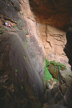
About 10 minutes further downcanyon, the slot jogs left and enters a section of cool, sculpted narrows with numerous rappels from fixed anchors. This is the Rock Narrows, and the count of "real rappels" begins here.
| |
|
| | An interesting old bolt in Mystery Canyon |
R1: 45 feet (15m) down a chute. Walk 40 feet.
R2: 30 feet (10m) down a chute. Slide down a short step. Walk about 50 feet (15m) downcanyon. A single, ancient bolt is positioned above a short, easy downclimb (8 feet (2.5m), 5.2). Twenty feet downcanyon, downclimb a log to a two-bolt anchor.
R3: 12 feet (4m) to the canyon floor. Walk 20 feet.
R4: Rap to a pothole, then down a lower slab (50 feet (15m)).
The canyon turns left and opens to the sun. Follow the slot 100 feet, including two short downclimbs, to a big log sticking vertically in the canyon.
R5: Rap 30 feet (10m) off a 2-bolt anchor next to a big log (!). Walk 50 feet, then downclimb a V slot to a 2-bolt anchor at a chockstone.
R6: Rap 40 feet (14m) down a slab to a pothole ledge. Walk 10 feet. Rappel off a single bolt (30 feet (10m)) or downclimb (5.6) to a round pothole.
| |
|
| |
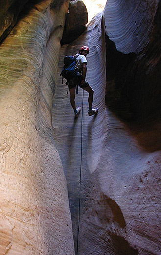
Rappelling in the dry slot section of Mystery Canyon.
| This is a good place for lunch - the next section of the canyon is in the full sun. Apply sunscreen.
The canyon opens up, with the impressive face of the Mountain of Mystery to the right. This section of canyon is often very hot. Follow the canyon past a few short scrambling sections to a flat area and a giant ponderosa log.
The flat area is the bed of a lake formed behind a giant landslide that crashed into the canyon sometime in the early 70’s (definitely before 1976). When the upper canyon flashes, sediment is brought down to the point where the canyon is blocked, then deposited to build a flat plain. This is what happened in Zion Canyon a couple thousand years ago, building a flat area from below Zion Lodge to the Temple of Sinawava.
Ascend the sandpile that blocks the canyon. A trail can be found, starting at the left margin and climbing diagonally across to the rock on the right. Drop down the far side of the sand pile, then carefully traverse a sandy ledge on the right side of the canyon, and downclimb back into the bottom. Follow the canyon for a few minutes to the top of a steep slab blocking the canyon.
R7: Rap 50 feet (15m) from bolts down a slab.
Follow the watercourse as the canyon tightens up. A short drop is bypassed by hopping over a rock on the right and downclimbing a chimney. Another short drop is passed by climbing under a log (the log itself is very slippery). By now, the canyon is delightfully shaded and cool. A few shallow pools are tiptoed around, then a groove followed to some larger pools. Stemming around these pools leads to a slot and the slabs at the top of Mystery Springs. Carefully climb left a few feet, then down to the comfortable pothole ledge. This is a good place to gear up for the last section of the canyon, and secure all your gear in drybags or kegs.
| |
|
| |
Little Bill splashing into Mystery Springs.
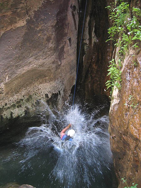
| This is the exciting rappel into Mystery Spring. The anchor is at the far end of the slab. A single bolt at the near end can be used to set up a safety line, or for belaying folks out to the rappel anchor. Getting to the anchor is only 3rd class, but rather exposed.
R8: Rappel 110 feet (33m) into the pool at the base of the wall. This is a bit tricky, because the rappeller must rap to the top of a boulder in the slot below, which is to the side of the fall line; then continue the rappel off the boulder, down a slippery slot and into the pool. There is a small chimney stance inches above the water where one can disconnect from the rope before swimming.
(The winter of 2004/2005 washed a lot of sand into this pool, and it was only waist deep in 2005. Hopefully, it will be restored to a full swim within a few years).
Also of note, there is an old bolt anchor in the pool behind the boulder in the slot. If someone does go down the back side of the boulder, there is an anchor available over there.
When pulling the rope, be sure it does not fall onto the boulder in the slot and get stuck. As it comes free, give it a gentle tug so the end falls towards you.
Note: if concerned about speed or ability, set up a guided rappel. By not having to make the top of the boulder or rappel the slippery slot below, those of lesser skill will move faster and easier through the rappel. A guided rappel can also be used to keep people out of the pool, but that’s no fun. The guided rappel plus safety line requires three sections of rope.
|
| |
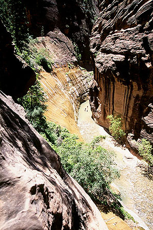
| Peering into The Narrows from Mystery Canyon. | | Downclimb a small cascade into a waist-deep pool. Further on, a boulder blocks the width of the canyon, creating a short drop with a turquoise pool below it.
There are several ways to deal with the pool. A small tree 10 feet back from the edge allows for a rappel. The chimney to the right can be downclimbed (5.6), though it is a little tricky. This pool used to be a good jump, but floods in 2005 washed a lot of sand into the pool, and it is now too shallow to jump.
Continue downcanyon, downclimbing a short waterfall. After a short walk through the jungle, you arrive at the final rappel down Mystery Falls into The Narrows.
R9: Rappel 120 feet (36m) from bolts down the slippery cascade to the river. Many an expert canyoneer has been embarrassed on this rappel – try not to be among them. This is a good place to provide a bottom-belay for all rappellers.
The Narrows is followed downcanyon about a half-mile (800m) to a stone structure (The Veranda) at the end of the paved trail. Follow the Gateway to the Narrows Trail one mile (1.6 km) to the Temple of Sinawava shuttle stop.
|